The Southern Ocean Observing System (SOOS) is an international initiative of the Scientific Committee on Antarctic Research (SCAR) and the Scientific Committee on Oceanic Research (SCOR). Developed over many years, SOOS was officially launched at the end of 2011 with the opening of the International Project Office, hosted by the Institute for Marine and Antarctic Studies (IMAS), and the Australian Research Council’s Antarctic Gateway Partnership at the University of Tasmania, Australia. Since then, SOOS has built a network of stakeholders and contributors, all working together to achieve the community-defined mission and objectives.
Objectives
SOOS Objectives are structured to follow a logical sequence of implementation: Design of the System, Capabilities, Observations, Regional Implementation, Data Deliver, Support Activities. For more information on the objectives and associated deliverables, please see the current 5-Year Implementation Plan.
- Facilitate the design and implementation of a comprehensive and multi-disciplinary observing system for the Southern Ocean
- Unify and enhance current observation efforts and leverage further resources across disciplines, and between nations and programs
- Facilitate linking of sustained long-term observations to provide a system of enhanced data discovery and delivery, utilising existing data centres and programmatic efforts combined with, as needed, purpose-built data management and storage systems
- Provide services to communicate, coordinate, advocate and facilitate SOOS objectives and activities
The SOOS Vision
The SOOS vision is that all stakeholders will have access to a sustained of observational coverage that will provide a foundation to advance understanding of the Southern Ocean and to address critical societal challenges.
In 2013, SOOS published its vision for the future, outlining the long-term goal of SOOS, the gains inherent in its implementation, and how the international community can move towards achieving it.
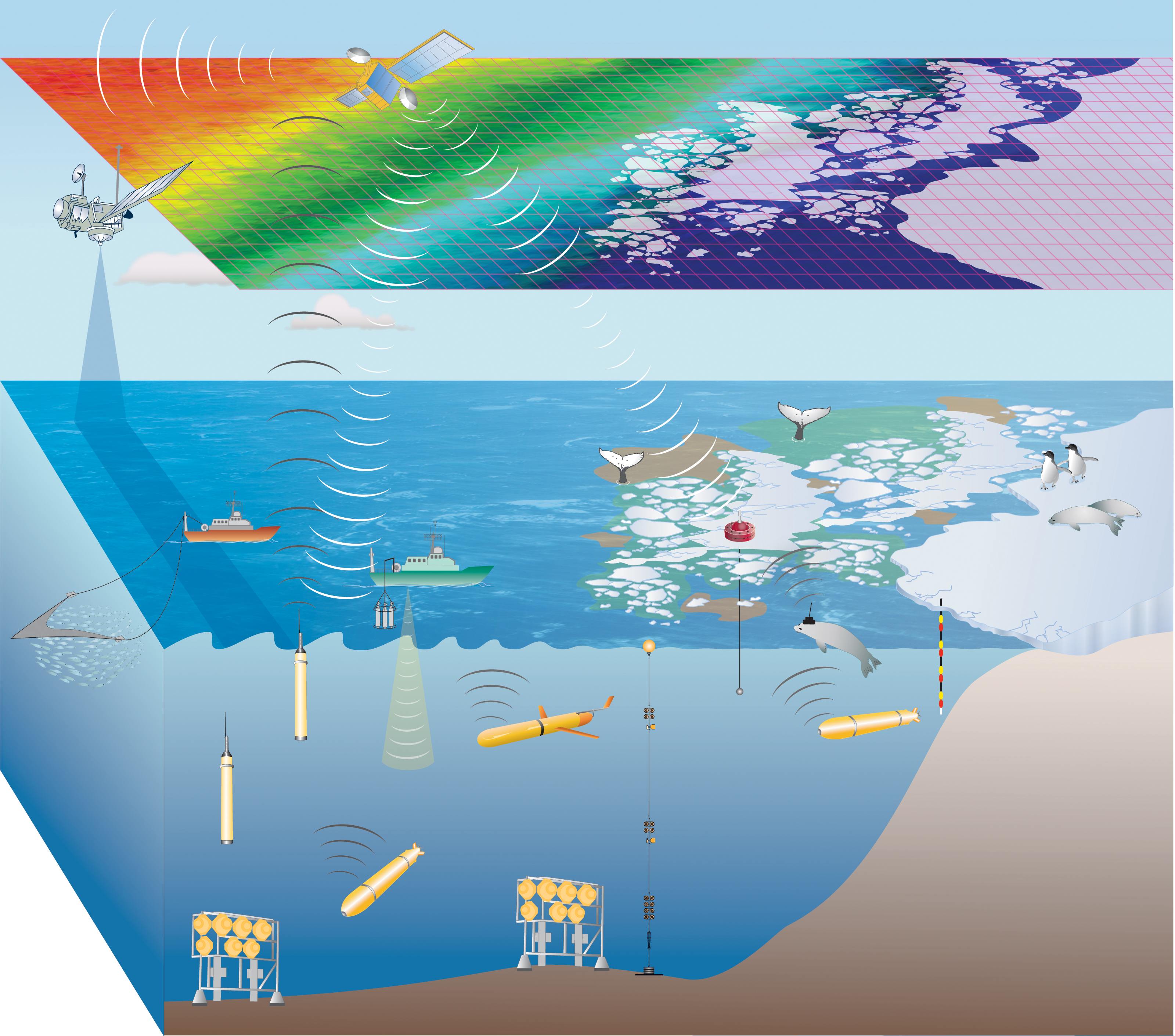
The SOOS vision is nicely summarised in this schematic. It shows a cyberinfrastructure-based vision for SOOS, where marine assets would include a mixture of both autonomous and non-autonomous platforms, but relying more heavily on the former over time. Combined with satellite remote sensing, the data would be relayed to ground stations in real time, where assimilating ocean models would produce near real-time state estimates of each of the parameters in the system. The error fields associated with these assimilating models would then be used to re-task the autonomous platforms in real time, thus maximising the spatial-temporal coverage of each of the parameters being measured, without specific need for human intervention.
The above vision is many years away, and it behoves us to work towards it progressively, yet strategically. Significant advances in cyberinfrastructure, modelling and observation technologies are needed to achieve the required capabilities. Further, international cooperation, infrastructure and investment are critical for the success of SOOS.
SOOS Products
SOOS is responsible for two SCAR Products:
- SOOSmap – an interactive map of standardised and aggregated datasets from the Southern Ocean.
- DueSouth – a database of planned expeditions to the Southern Ocean.
Learn more about SOOS by visiting their website: www.soos.aq


")
