The SCAR Expert Group on Geological Heritage and Geoconservation (EG-GEOCON) is comprised of Antarctic Earth Science and Protected Area specialists from around the globe. The group’s main purpose is to advance the identification of Antarctic geological sites of exceptional value to be designated geological heritage of international relevance, and to contribute to SCAR advice to the CEP and the ATCM on matters related to conservation of geological heritage.
Aims, Goals and Objectives
The Expert Group:
- Will complete the formal identification of Geosites within the different Geological Frameworks begun by the previous Action Group.
- Will advise SCAR on Antarctic geological sites or elements of exceptional interest and about conservation needs in proposals presented to the CEP and the ATCM.
- Will maintain an updated list of repositories of geological specimens and will promote their use by the geosciences community. It would be helpful to our purpose if the repositories provided approximate numbers and types of samples or other broad information for each Geosite along with a hyperlink.
Background:
In the Information Paper linked above SCAR presented a summary of a recent academic review, led by members of the SCAR Action Group on Geological Heritage and Geoconservation, which describes current threats to Antarctic geological features and details existing systems for their protection. The aim of the Information Paper was to inform the CEP about progress connected with the topic of conservation of Antarctic geological features, about which SCAR has agreed to present a comprehensive paper in 2018.
At CEP XVII, the United Kingdom, Argentina, Australia and Spain introduced ATCM XXXVII WP35, which discussed the Antarctic Protected Area system in relation to the protection of sites of geological significance (which includes geomorphological and paleontological sites). One recommendation was that SCAR consider requirements for the protection of geological features. SCAR highlighted its newly formed Action Group (AG) on Geological Heritage and Geoconservation, and indicated that it would report back to the CEP. SCAR agreed to submit to the CEP a comprehensive paper about the aforementioned topic in 2018. In light of a recent paper (Hughes et al., 2016) concerning Antarctic geoconservation, SCAR presented the initial appraisal of findings , upon which subsequent SCAR outputs on this topic may build. It was anticipated that the Information Paper may inform, promote and facilitate future discussion within the CEP on the issue.
Antarctic geological heritage and geoconservation:
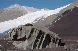
Geological heritage is, broadly speaking, the recognition and identification of geological, paleontological and geomorphological features that possess aesthetic, intrinsic or scientific and educational value, and that provide illustration of geological processes and insight into the formation and evolution of the Earth. Antarctica’s geology has advanced scientific knowledge on topics of global importance, including plate tectonics and the evolution of life and past climates, making appropriate protection of outstanding geological examples essential. The prohibition of mineral resource activities through the Protocol on Environmental Protection to the Antarctic Treaty has removed one significant source of potential damage to Antarctica’s geological and geomorphological values. However, given increasing Antarctic tourism and scientific activities, some significant geological features may be vulnerable to human impacts, such as inadvertent damage due to foot or vehicle traffic, infrastructure development, unregulated collection, the taking of geological specimens as souvenirs, or potential oversampling for scientific purposes. Geological features for which consideration of enhanced protection and/or special recognition could be appropriate may include:
- outcrops containing rare or unique minerals (e.g. rare boron and phosphate minerals in Antarctic Specially Protected Area (ASPA) No. 174 Stornes, Larsemann Hills, Princess Elizabeth Land);
- areas of blue ice where concentrations of meteorites are found (e.g. the Frontier Mountain blue ice field);
- ice-free areas or blue ice moraines that have unusually high potential to be used for cosmogenic dating
- (as has been done using geological material from the Heritage Range and Grove Mountains);
- rare, unique or vulnerable glacial and/or geomorphological features (such as protected within ASPA No. 168 Mount Harding);
- representative sections of unique or particularly well-exposed stratigraphy (e.g. the Cretaceous– Paleogene boundary located within the James Ross Island group);
- unique or exceptional examples of rock structures (e.g. unconformities, folds, faults and intrusive relationships, e.g. Vestfold Hills, Prydz Bay; Finger Mountain, Transantarctic Mountains);
- locations where rare or unique fossils (including trace fossils) and fossil beds are found (e.g. ASPA No. 148 Mt Flora, ASPA No. 125 Fildes Peninsula, ASPA No. 143 Marine Plain; Miocene penguin fossil site, Fisher Massif, Prince Charles Mountains);
- the ‘type locality’ for a rock type, stratigraphic unit, fossil or mineral (the site where that particular feature is first described in the scientific literature);
- landforms such as raised beaches, patterned ground and unconsolidated soils of particular value, which may be vulnerable to relatively low levels of human impacts, including trampling (e.g. protected as a secondary value within ASPA No. 122 Arrival Heights, Hut Point Peninsula, Ross Island);
- ‘geo-cultural’ sites, which are significant localities in the history of geosciences (e.g. Dallwitz Nunatak, Enderby Land, where the high temperature mineral assemblage, sapphirine + quartz, was first identified).
Annex V to the Protocol provides a framework for the protection of Antarctica’s geological features and specifically recognises ‘examples of outstanding geological, glaciological and geomorphological features’ (Article 3.2f). Available management tools include Antarctic Specially Protected Areas (ASPAs) and Antarctic Specially Managed Areas (ASMAs). More recently, Site Guidelines for Visitors (SGVs) have been developed for areas receiving high levels of tourism industry and national operator visitation. The Antarctic Protected Area system is still evolving and further implementation of existing management tools may be required to protect the diverse range of vulnerabilities, qualities and spatial scales represented in the geology and geomorphology of the continent. Development of management protocols for individual geological sites of significance would necessitate case-by-case consideration as, while some important outcrops are extremely robust to damage, others are far less so and easily damaged by foot traffic. ‘Recoverability’ of sites to various levels of disturbance also needs to be considered and assessed. Nevertheless, the requirement for a permit to access ASPAs may make ASPA designation for some ‘robust’ geological and geomorphological features seem somewhat excessive, while ASMAs and SGVs may simply not be appropriate tools for use outside areas of high human activity. Therefore, it is not always clear how existing tools could be used to protect geological and geomorphological features of an important but less outstanding nature, or those of a larger spatial scale.
The Environmental Impact Assessment (EIA) process is an important tool for geoconservation; for example, at sites where high-quality mineralogical or palaeontological specimens exist in limited quantities, considerations of how best to prevent oversampling and manage access to remaining material may be supported by assessment of cumulative impacts. Research to examine the level of Antarctic specimen loans from a selection of national geological collections suggested that publically accessible geological collections could be better utilized, which could potentially reduce environmental impacts and oversampling at some vulnerable Antarctic sites.
Concluding Remarks:
In order to protect Antarctica’s significant geological and palaeontological localities and specimens for future scientific study, consideration should be given to:
- the criteria, protocols and mechanisms for geoconservation on a case-by-case basis;
- improved recording of metadata, field locations of specimens and features;
- sharing of information on existing geological material that has been sampled;
- greater use of specimens in existing geological collections, where appropriate;
- how sites of geological, geomorphological and palaeontological significance should be identified and recognized and information concerning their potential vulnerabilities communicated;
- better monitoring of sampling impacts at vulnerable sites to inform best-practice environmental management decisions.
Reference:
Hughes, K. A., López-Martínez, J., Francis, J. E., Crame, J. A., Carcavilla, L., Shiraishi, K., Hokada, T., and Yamaguchi, A. 2016. Antarctic geoconservation: a review of current systems and practices. Environmental Conservation. DOI: https://doi.org/10.1017/S0376892915000387


