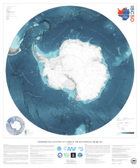
Digital Bathymetric Model (DBM)
The digital bathymetric model (DBM) of IBCSO Version 2.0 has a 500m x 500m resolution based on a polar stereographic projection (EPSG: 9354) for the area south of 50° S. It is publicly available together with a digital chart for printing.
The projection used for IBCSO v2 was registered in April 2020 under EPSG: 9354.
A .prj file containing the projection string can be downloaded from the PANGAEA website.
If you are using any data from IBCSO v2, please use the following citation:
Dorschel, Boris; Hehemann, Laura; Viquerat, Sacha; Warnke, Fynn; Dreutter, Simon; Schulze Tenberge, Yvonne; Accetella, Daniela; An, Lu; Barrios, Felipe; Bazhenova, Evgenia A; Black, Jenny; Bohoyo, Fernando; Davey, Craig; de Santis, Laura; Escutia Dotti, Carlota; Fremand, Alice C; Fretwell, Peter T; Gales, Jenny A; Gao, Jinyao; Gasperini, Luca; Greenbaum, Jamin S; Henderson Jencks, Jennifer; Hogan, Kelly A; Hong, Jong Kuk; Jakobsson, Martin; Jensen, Laura; Kool, Johnathan; Larin, Sergey; Larter, Robert D; Leitchenkov, German L; Loubrieu, Benoit; Mackay, Kevin; Mayer, Larry; Millan, Romain; Morlighem, Mathieu; Navidad, Francisco; Nitsche, Frank-Oliver; Nogi, Yoshifumi; Pertuisot, Cécile; Post, Alexandra L; Pritchard, Hamish D; Purser, Autun; Rebesco, Michele; Rignot, Eric; Roberts, Jason L; Rovere, Marzia; Ryzhov, Ivan; Sauli, Chiara; Schmitt, Thierry; Silvano, Alessandro; Smith, Jodie E; Snaith, Helen; Tate, Alex; Tinto, Kirsty; Vandenbossche, Philippe; Weatherall, Pauline; Wintersteller, Paul; Yang, Chunguo; Zhang, Tao; Arndt, Jan Erik (2022): The International Bathymetric Chart of the Southern Ocean Version 2 (IBCSO v2). PANGAEA, doi: 10.1594/PANGAEA.937574
The accompanying publication was published in Nature Scientific data:
Dorschel B, Hehemann L, Viquerat S, Warnke F, Dreutter S, Schulze Tenberge Y, Accetella D, An L, Barrios F, Bazhenova EA, Black J, Bohoyo F, Davey C, de Santis L, Escutia Dotti, Carlota Fremand AC, Fretwell PT, Gales JA, Gao J, Gasperini L, Greenbaum JS, Henderson Jencks J, Hogan KA, Hong JK, Jakobsson M, Jensen L, Kool J, Larin S, Larter RD, Leitchenkov GL, Loubrieu B, Mackay K, Mayer L, Millan R, Morlighem M, Navidad F, Nitsche FO, Purser A, Rebesco M, Rignot E, Roberts JL, Rovere M, Ryzhov I, Sauli C, Schmitt T, Silvano A, Smith JE, Snaith H, Tate AJ, Tinto K, Vandenbossche P, Weatherall P, Winterstellar P, Yang C, Zhang T, Arndt JE (2022): International Bathymetric Chart of the Southern Ocean Version 2 (IBCSO v2). doi: 10.1038/s41597-022-01366-7
Database
The IBCSO database currently consists of more than 25 billion data points contributed by 88 institutions from 22 countries. In total, 498 multibeam and 950 singlebeam echo sounding data were building the core data of our database. Digitized soundings from nautical charts, LIDAR, gravity data and regional bathymetric compilations are rounding off the database. A list of datasets used for the compilation of IBCSO v2 can be downloaded here:
Coverage
An overview of included data sources and the spatial distribution can be seen in the source identification map (above right).
The IBCSO group aims to identify data gaps and areas that suffer from low data quality, such as outdated singlebeam data. The IBCSO TID grid can be used to identify areas with high quality multibeam. For an easier access to this information, we also provide a GIS-ready geopackage showing the outline of multibeam and singlebeam surveys contained in IBCSO v2 here:
Data Contributions
If you are holding bathymetric data that is not yet included in the IBCSO database, we encourage you to contribute your data to improve the IBCSO digital bathymetric model for the benefit of all. Contributed data will be acknowledged and will only be used to generate the IBCSO digital bathymetric model. To contribute data, please contact us.
Cartography data
To enable users to visualize their own data on a map with the IBCSO look and feel, we are offering the base data of the IBCSO printable chart as a georeferenced image. The ‘Background’ maps contain RGB rasterfiles in GeoTiff format, which is compatible with most GIS programs.

")