ADMAP was launched in 1995 to compile and integrate into a digital database all exisiting near-surface and satellite mangetic anomaly data collected in Antarctica and surrounding oceans south of 60 degrees. Since then, the ADMAP has been updating the databases with additional surveys as well as investigating the areas of special interest.
A series of databases have been made available:
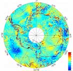 ADMAP-CNSO-OSU02
This map was generated using ADMAP near-surface compilation and Orsted satellite total intensity anomaly data (Kim, 2002) at 700 km. The surface gaps were augmented by the algorithm in Kim et al. (2004) for the wavelengths larger than 400 km. Details about this map was described in Kim et al.(2004).
The grid data for this map in ASCII format as a compressed ZIP file is available here (4.3 Mb).
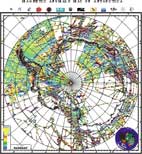
 ADMAP 2001
This map was generated using ADMAP near-surface compilation and Magsat satellite total intensity anomaly data at 400 km. The surface gaps were augmented by equivalent point diple source technique for the wavelengths larger than 400 km.
The grid data (5 km interval) for this map in ASCII format is available here as a zipped file (14.9 Mb).
The image file for this map in CorelDraw version is available here as a zipped file (14.4 Mb).
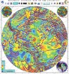
 ADMAP 2001
This map was generated using ADMAP near-surface compilation data collected by all ADMAP WG and finalized by Dr. Golynsky (Golynsky et al., 2002).
The grid data (5 km interval) for this map in ASCII version is available here as a zipped file (9.4 Mb).
The image file for this map in CorelDraw version is available here as a zipped file (21.3 Mb).
The databases are also available at the ADMAP website.